 Summary Data and Statistics
Summary Data and Statistics
Summary Data and Statistics
The following is a .zip file. File type (in bold), default file names (in italics), and file
sizes are given. The disclaimer shown below pertains to any and all data downloaded from the WVGES
Web site.
ESRI Shapefile Format** * Please note that at this time, distribution of geospatial data from the WVGES Web site does not
meet Federal Geographic Data Committee standards.
** ESRI shapefiles can be used readily in various ESRI products including
ArcView and
ArcExplorer. ArcView is a desktop mapping and GIS software package. ArcExplorer is a GIS data viewer that is available free
of charge from the ESRI Web site. Detailed documentation about ArcExplorer is available from ESRI as well.
1. We believe the data in the WVGES computer databases to have been generated and assembled with a high degree of professionalism,
accuracy, and precision for the purposes for which they were originally intended. In this context, "data" refer to numerical and
textual data (such as in the "pipeline" application), digitial data (such as .las files), digital images (such as digital photographs),
scanned records (such as completion reports), and spatial data (such as shapefiles). Some data have been compiled from other sources
and the WVGES accepts no responsibility for any inaccuracies in those data. Therefore, we cannot and do not, either implicitly or
explicitly, guarantee the accuracy, precision, or completeness of the data.
2. Neither the WVGES nor its staff members are liable or responsible for any damage or loss resulting from the use of the databases
or from inaccuracies contained in the databases.
3. These data are provided as a service to the State of West Virginia through the WVGES for the purpose of research and development
efforts. Final use of these data is the sole responsibility of the user.
4. We encourage you to report any problems, inconsistencies, or errors noted in using these data to the Computing Services Program,
so that we can correct them and provide even better service.
Please send questions, comments, and/or suggestions to webmaster. Permission to reproduce this material is granted if acknowledgment is given
to the West Virginia Geological and Economic Survey.
Datum: NAD 1927 (NAD 27), Projection: UTM, Zone: 17, Units: meters (after importing .shp files, the data units may need to be defined using
View Properties within ESRI software)
downloadable .zip file, mrbg_shp.ZIP: 1,918 KB
contains
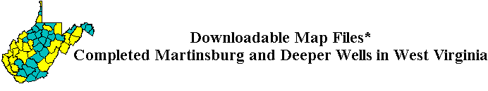
Completed Martinsburg (Ordovician) and Deeper Wells in West Virginia (total of 41 wells)
mrbg_p99.dbf: 44 KB,
mrbg_p99.prj: 1 KB,
mrbg_p99.sbn: 1 KB,
mrbg_p99.sbx: 1 KB,
mrbg_p99.shp: 2 KB, and
mrbg_p99.shx: 1 KB
Outlines of West Virginia Counties
counties.dbf: 18 KB,
counties.prj: 1 KB,
counties.sbn: 1 KB,
counties.sbx: 1 KB,
counties.shp: 2,466 KB, and
counties.shx: 1 KB,
15-Minute Quadrangle Tic Marks for West Virginia
tics.dbf: 9 KB,
tics.prj: 1 KB,
tics.sbn: 2 KB,
tics.sbx: 1 KB,
tics.shp: 4 KB, and
tics.shx: 2 KB
![]()
![]()
DISCLAIMER REGARDING THE RELEASE OF DATA AND USER REQUIREMENTS
The West Virginia Geological and Economic Survey (WVGES) makes basic data available to the public from its computerized
databases on mineral resources under the following conditions:
West Virginia Geological and Economic Survey
(304)594-2331
webmaster@wvgs.wvnet.edu
Page created and maintained by:
            West Virginia Geological and Economic Survey
  Address:  Mont Chateau Research Center
            1 Mont Chateau Road
            Morgantown, WV  26508-8079
Telephone:  304-594-2331
      FAX:  304-594-2575
    Hours:  8:00 a.m. - 5:00 p.m. EST, Monday - Friday